Urbex Map Illinois – Urban Exploration USA GPS Map
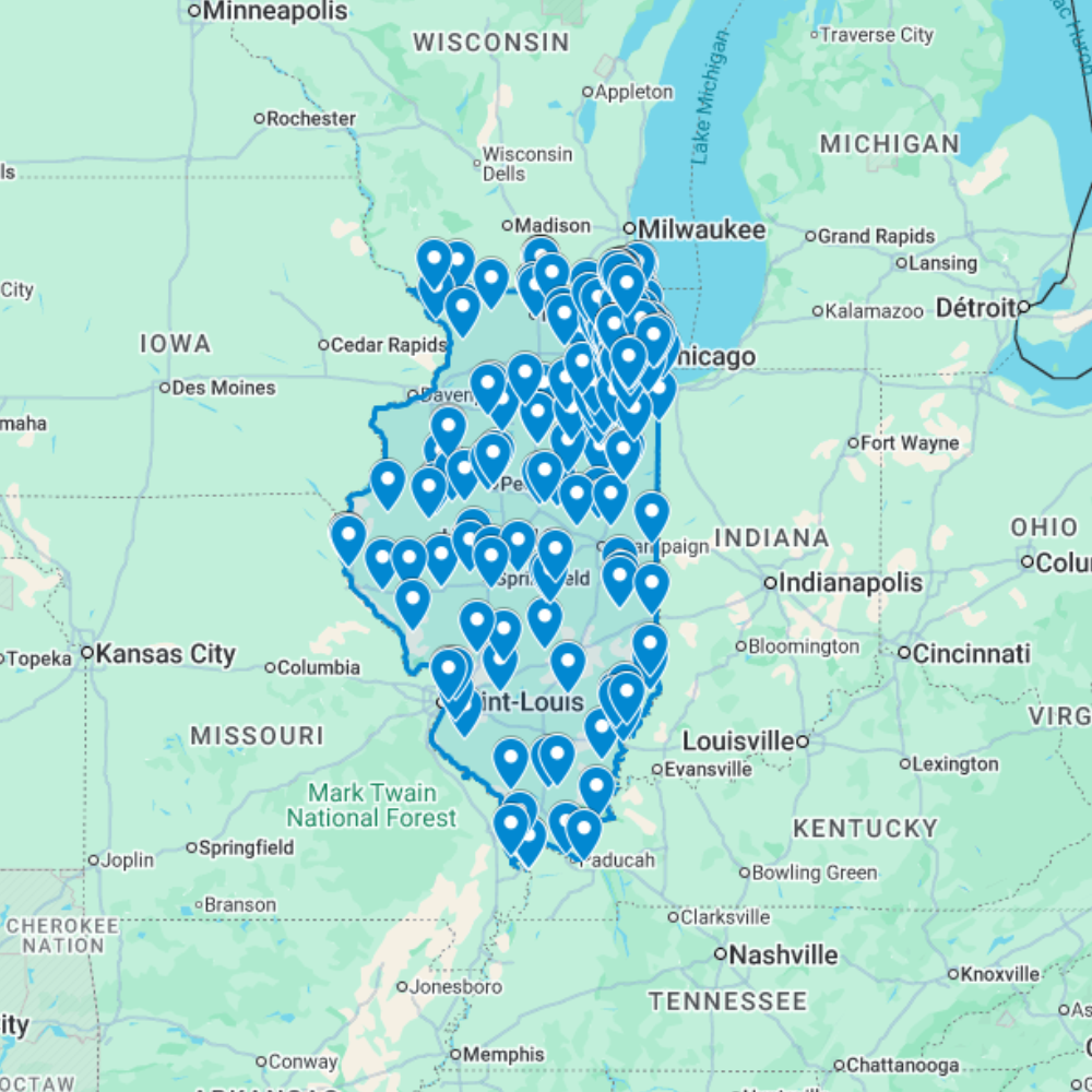
The Urbex Map Illinois is a detailed and structured abandoned places map covering the entire state of Illinois. It compiles 229 verified urban exploration spots into a practical and easy-to-use GPS file format.
Instead of spending hours searching through outdated forums, scattered coordinates, or unreliable online sources, this urban exploration map centralizes essential location data into one organized digital database. Each entry helps explorers quickly identify potential abandoned buildings and plan photography sessions or exploration routes efficiently.
This urbex map includes a wide range of urban exploration spots such as industrial sites, former public buildings, forgotten infrastructure, and historic properties. By using a structured GPS map, explorers can significantly reduce research time and organize their exploration routes more effectively.
For urban explorers, photographers, filmmakers, and content creators, having a reliable abandoned places map of Illinois provides a valuable advantage for planning documentary work and visual storytelling.
Cities & Regions Included
- 🏙️ Chicago & Greater Metro : Chicago and its suburbs contain some of the most dramatic abandoned industrial complexes in the United States, including former steel mills, meatpacking plants, factory buildings, and decaying warehouse districts across the urban landscape.
- 🏭 Peoria & Central Illinois : Peoria and central Illinois feature abandoned manufacturing plants, former agricultural processing facilities, decaying historic downtown commercial districts, and industrial structures tied to the region’s manufacturing heritage.
- 🏛️ Springfield & Capital Region : Springfield and the capital region contain former institutional buildings, abandoned state facilities, decaying historic commercial properties, and structures reflecting the administrative and political history of Illinois.
- 🌾 Southern Illinois & Rural Areas : Southern Illinois features abandoned coal mining operations, former industrial towns, decaying rural farmsteads, and isolated structures reflecting the region’s mining and agricultural heritage across the Illinois Ozarks and river valleys.
Types of Spots Included
This urbex map includes a wide variety of abandoned locations such as hospitals, factories, warehouses, mansions, schools, hotels, industrial plants, office buildings, transportation facilities, and former institutional buildings. Some entries feature large industrial complexes, while others highlight smaller forgotten buildings with historical or architectural significance. The diversity of locations provides excellent opportunities for photography, filming, and urban exploration documentation.
Why Choose This Urbex Map?
✔️ Verified and organized abandoned locations
✔️ Structured digital GPS format
✔️ Instant access after purchase
✔️ Saves extensive research time
✔️ Large structured database (229 spots)
✔️ Designed for serious urban explorers and content creators
Technical Specifications
- File Format: .KML / .KMZ
- Instant Digital Download
- Compatible with Google Earth
- Compatible with Google My Maps
- Works on Desktop & Mobile Devices
- Digital Product Only (No physical item shipped)
How to Install
- Complete your purchase and download the .KML or .KMZ file.
- Open Google Earth or go to Google My Maps in your browser.
- Import the downloaded file into the platform.
- Browse the GPS locations and plan your exploration routes.
Installation takes less than two minutes and works on both desktop and mobile platforms.
Reviews
There are no reviews yet.