Urbex Map Iowa – Urban Exploration USA Map
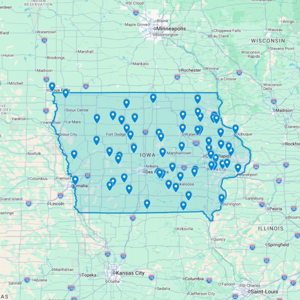
The Urbex Map Iowa brings together 67 verified GPS locations distributed across the state’s most historically significant regions. Whether you’re searching for urbex near me or planning a multi-day route, this map gives you direct access to structured, ready-to-use coordinates.
From the industrial facilities of Des Moines to the grain processing plants of Cedar Rapids and the manufacturing plants found throughout Davenport, this map covers the full spectrum of abandoned places that Iowa has to offer.
Every listed location is organized into a structured GPS file, giving photographers, filmmakers, and urban explorers reliable coordinates and a direct research advantage when planning routes or documentation projects anywhere in Iowa.
Cities & Regions Included
- Des Moines & Central Iowa : Des Moines and central Iowa contain abandoned industrial facilities, former meat processing plants, decaying historic warehouse districts, and forgotten commercial buildings shaped by the city’s agricultural processing heritage.
- Cedar Rapids & Eastern Iowa : Cedar Rapids and eastern Iowa feature former grain processing plants, abandoned manufacturing facilities, decaying small-town commercial districts, and industrial structures tied to the region’s agricultural economy.
- Davenport & Quad Cities : The Davenport area and Quad Cities contain abandoned manufacturing plants, former waterfront industrial facilities, decaying historic downtown structures, and forgotten buildings along the Mississippi River corridor.
- Western Iowa & Rural Areas : Western Iowa and rural areas feature abandoned farming operations, former rural commercial centers, decaying agricultural infrastructure, and isolated farmsteads reflecting the state’s deep agricultural heritage.
Types of Spots Included
This urbex map documents a variety of abandoned locations specific to Iowa, including industrial facilities, meat processing plants, historic warehouse districts, grain processing plants, and other forgotten structures of historical and architectural interest. Additional entries cover manufacturing facilities and small-town commercial districts, reflecting the depth of Iowa’s abandoned landscape. The range of sites across the state creates strong opportunities for urbex photography, film scouting, and documentary documentation.
Why Choose This Urbex Map?
- 📍 67 GPS-ready locations in one organized file
- 📡 Direct import to Google Earth and Google My Maps
- ⚡ Available immediately after purchase
- ⏱️ Skip hours of online research with a single download
- 🎯 Built for serious field explorers and content creators
- 📷 Ideal for photography routes, film scouting, and visual documentation
Technical Specifications
- Format: .KML / .KMZ (GPS file)
- Access: Instant digital download
- Platforms: Google Earth, Google My Maps
- Devices: Desktop and mobile compatible
- Delivery: Digital file – no physical shipment
- Compatibility: Works on all major operating systems
How to Install
- Purchase and download your .KML or .KMZ file immediately after checkout.
- Launch Google Earth on your device, or open Google My Maps in any browser.
- Use the import or open file option to load the GPS file into the platform.
- Navigate through the mapped locations and start building your exploration plan.
The entire setup process takes under two minutes and is compatible with both desktop and mobile devices.
Reviews
There are no reviews yet.