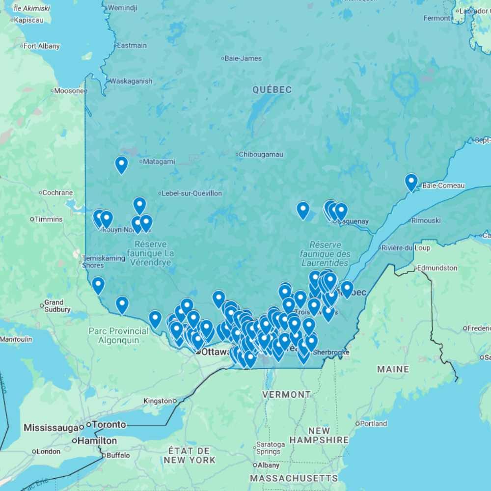
Urbex Map Quebec – Urban Exploration Canada Map
The Urbex Map Quebec documents 257 verified GPS locations across Canada’s most culturally distinctive province. From the extraordinary psychiatric hospital complexes of Montreal’s east end to the former asbestos mining towns of the Eastern Townships and the abandoned resort hotels of the Laurentians, this map covers a province where French-Canadian institutional architecture and industrial heritage create exploration environments found nowhere else in North America.
Quebec’s abandoned landscape reflects two centuries of industrial development shaped by the province’s unique cultural and economic history: the textile and railway industries that defined Montreal’s east end, the resource extraction economy that built and then emptied towns across the Laurentian Shield, and the distinctive tradition of Catholic institutional architecture that produced hospitals, orphanages, convents, and asylums of remarkable scale and visual complexity.
Structured for direct import into Google Earth or Google My Maps, this GPS database gives urban explorers, photographers, and documentary filmmakers a verified research tool for navigating Quebec’s abandoned sites, from Montreal’s industrial waterfront to the remote mining towns of the northern Shield.
Cities & Areas Included
- 🏭 Montreal & the Industrial East End : Montreal’s former industrial east end holds some of the most significant abandoned manufacturing infrastructure in Canada: decommissioned textile mills along the Saint Lawrence waterfront, former railway yards and locomotive repair shops across Pointe-Saint-Charles and Rosemont, and abandoned institutional buildings including the extraordinary Hôpital Saint-Jean-de-Dieu complex, one of the largest former psychiatric institutions in North America, with over 60 buildings on a single campus.
- 🏛️ Quebec City & the Historic Fringe : Quebec City and its surrounding region hold former military fortifications from the colonial and early Canadian periods, decommissioned industrial buildings along the Saint Lawrence below the city, and forgotten rural manor houses and mills across the Côte-de-Beaupré and Charlevoix areas. The Lévis industrial waterfront adds former shipyard infrastructure, while the South Shore contributes decommissioned asbestos processing facilities and forgotten company towns from Quebec’s resource extraction era.
- 🌲 Laurentians, Eastern Townships & Remote Quebec : Northern Quebec and the Laurentian region hold abandoned resort hotels, former logging camps, decommissioned mining towns, and isolated industrial sites across the Canadian Shield. The Eastern Townships add former woollen mills, abandoned institutional buildings, and forgotten railway infrastructure from the region’s late 19th-century industrial expansion. Some sites in the remote Abitibi region, former gold and copper mining towns established in the 1930s, have been largely untouched for decades.
Types of Spots Included
This urbex map covers Montreal’s former textile mills, railway infrastructure, and psychiatric hospital complexes, former asbestos and mineral extraction towns in the Eastern Townships and Abitibi, abandoned Laurentian resort hotels and lodge complexes, decommissioned Catholic institutional buildings across the province, former pulp and paper mill infrastructure along major river corridors, and isolated mining camps across the northern Quebec Shield. Quebec’s institutional and industrial heritage creates urbex environments of distinctive architectural and historical character.
Why Choose This Urbex Map?
- 📍 257 GPS-ready locations in one organized file
- 📡 Direct import to Google Earth and Google My Maps
- ⚡ Available immediately after purchase
- ⏱️ Skip hours of forum research with a single download
- 🎯 Built for field explorers, photographers, and filmmakers
- 📷 Ideal for photography routes, film scouting, and visual documentation
Technical Specifications
- Format: .KML / .KMZ (GPS file)
- Access: Instant digital download
- Platforms: Google Earth, Google My Maps
- Devices: Desktop and mobile compatible
- Delivery: Digital file, no physical shipment
- Compatibility: Works on all major operating systems
How to Install
- Purchase and download your .KML or .KMZ file immediately after checkout.
- Launch Google Earth on your device, or open Google My Maps in any browser.
- Use the import or open file option to load the GPS file into the platform.
- Navigate through the mapped locations and start building your exploration plan.
The entire setup process takes under two minutes and is compatible with both desktop and mobile devices.

Reviews
There are no reviews yet.