Urbex Map New Brunswick – Urban Exploration Canada Map
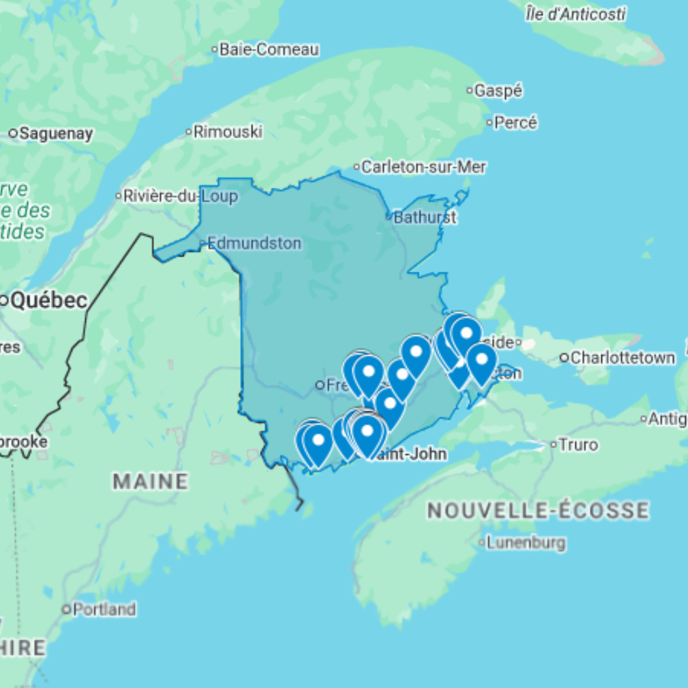
The Urbex Map New Brunswick documents 34 verified GPS locations across Canada’s only officially bilingual province, a Maritime territory defined by forestry, fishing, and port industrial heritage. From the former dry docks and industrial waterfront of Saint John to the river valley sawmill ruins of the Miramichi, this map covers New Brunswick’s full range of abandoned industrial sites.
New Brunswick’s abandoned landscape reflects the province’s dependence on resource extraction: the square timber trade that cleared the province’s forests in the 19th century, the pulp and paper industry that industrialised the same landscape in the 20th, and the coastal fishing heritage that built and then emptied dozens of small communities along the Bay of Fundy and Northumberland Strait. Each phase left behind distinct categories of infrastructure now in varying states of abandonment.
Structured for direct import into Google Earth or Google My Maps, this GPS database gives urban explorers and photographers a verified research tool for navigating New Brunswick’s abandoned sites across both English and French-speaking regions of the province.
Cities & Areas Included
- 🏭 Saint John Industrial Heritage : Saint John, New Brunswick’s largest city, holds former dry dock facilities, decommissioned sugar refinery infrastructure, and abandoned industrial buildings from the city’s 19th and early 20th-century manufacturing era. The Uptown area and the industrial waterfront preserve decommissioned warehousing and processing buildings of considerable scale, while the west side of the city holds former railway infrastructure and industrial complexes associated with the port.
- 🌲 Miramichi Lumber Mills & Forest Industry : The Miramichi River valley and the broader New Brunswick interior hold former sawmill complexes, decommissioned pulp and paper infrastructure, and abandoned company facilities from the province’s long forestry industry history. The lumber industry that defined New Brunswick’s 19th-century economy left behind mill infrastructure along every major river in the province, some dating to the square timber trade era, others to the 20th-century pulp era, all in varying states of decay.
Types of Spots Included
This urbex map covers former Saint John dry dock and port industrial infrastructure, decommissioned pulp mill and sawmill complexes along the Miramichi, Saint John, and other river valleys, abandoned coastal fishing wharves and processing plants along the Bay of Fundy and Northumberland Strait, former railway infrastructure including repair shops and divisional facilities, and forgotten rural heritage buildings across the province’s agricultural and forested interior.
Why Choose This Urbex Map?
- 📍 34 GPS-ready locations in one organized file
- 📡 Direct import to Google Earth and Google My Maps
- ⚡ Available immediately after purchase
- ⏱️ Skip hours of forum research with a single download
- 🎯 Built for field explorers, photographers, and filmmakers
- 📷 Ideal for photography routes, film scouting, and visual documentation
Technical Specifications
- Format: .KML / .KMZ (GPS file)
- Access: Instant digital download
- Platforms: Google Earth, Google My Maps
- Devices: Desktop and mobile compatible
- Delivery: Digital file, no physical shipment
- Compatibility: Works on all major operating systems
How to Install
- Purchase and download your .KML or .KMZ file immediately after checkout.
- Launch Google Earth on your device, or open Google My Maps in any browser.
- Use the import or open file option to load the GPS file into the platform.
- Navigate through the mapped locations and start building your exploration plan.
The entire setup process takes under two minutes and is compatible with both desktop and mobile devices.
Reviews
There are no reviews yet.