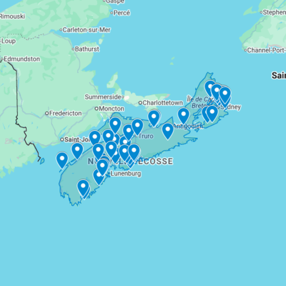
Urbex Map Nova Scotia – Urban Exploration Canada Map
The Urbex Map Nova Scotia documents 50 verified GPS locations across the Maritime province, a territory defined by the extraordinary coal and steel industrial heritage of Cape Breton and the scattered maritime fishing infrastructure of the Nova Scotia coastline. From the former Sydney Steel plant ruins to the abandoned coal mine headframes of the Sydney Coalfield, this map covers Atlantic Canada’s most significant industrial abandoned landscape.
Nova Scotia’s abandoned heritage is anchored by Cape Breton’s coal and steel industry: the mining infrastructure that supported over a century of extraction across the Sydney Coalfield, and the steel plant complex that processed Cape Breton coal into Canadian steel until economic and environmental pressures forced closure in the late 20th century. Combined with the province’s maritime fishing and military heritage, Nova Scotia offers a compact but historically rich abandoned landscape.
Structured for direct import into Google Earth or Google My Maps, this database gives urban explorers, photographers, and documentary crews a verified research tool for navigating Nova Scotia’s abandoned sites, from the industrial ruins of Cape Breton to the coastal fishing heritage of the province’s fishing communities.
Cities & Areas Included
- ⚒️ Cape Breton Coal Mines & Steel Industry : Cape Breton Island holds the most significant abandoned coal mining and steel industry infrastructure in Atlantic Canada: former Dominion Coal Company collieries across the Sydney Coalfield, the extraordinary ruins of the Sydney Steel Corporation (SYSCO) plant at Sydney, once one of the largest integrated steel mills in Canada, and the decommissioned Devco mining infrastructure across communities like New Waterford, Glace Bay, and Dominion. The industrial scale of Cape Breton’s abandoned infrastructure, set against the island’s dramatic coastal landscape, creates exploration environments found nowhere else in the Maritime provinces.
- 🌊 Maritime Heritage & Coastal Industrial Sites : Nova Scotia’s extensive coastline holds former fish processing plants, abandoned canneries, decommissioned wharves, and forgotten maritime industrial infrastructure across dozens of small coastal communities. The South Shore and Fundy coast add former textile mills, abandoned rum-running infrastructure from the Prohibition era, and decommissioned military coastal installations. Halifax adds former dockyards, industrial waterfront buildings, and decommissioned military infrastructure from the city’s long naval heritage.
Types of Spots Included
This urbex map covers former coal mine headframes, pit buildings, and colliery infrastructure across the Cape Breton Sydney Coalfield, the former Sydney Steel (SYSCO) integrated steel plant complex, abandoned fish processing plants and maritime infrastructure along the Nova Scotia coastline, former Halifax waterfront industrial and military facilities, and decommissioned Prohibition-era coastal infrastructure. Nova Scotia’s Cape Breton coal and steel ruins represent the most significant category of industrial heritage in Atlantic Canada.
Why Choose This Urbex Map?
- ✔️ 50 verified and organized abandoned locations
- ✔️ Structured digital GPS format (.KML / .KMZ)
- ✔️ Instant access after purchase
- ✔️ Saves extensive research time
- ✔️ Compatible with Google Earth and Google My Maps
- ✔️ Designed for serious urban explorers and content creators
Technical Specifications
- File Format: .KML / .KMZ
- Instant Digital Download
- Compatible with Google Earth
- Compatible with Google My Maps
- Works on Desktop & Mobile Devices
- Digital Product Only (No physical item shipped)
How to Install
- Complete your purchase and download the .KML or .KMZ file.
- Open Google Earth or go to Google My Maps in your browser.
- Import the downloaded file into the platform.
- Browse the GPS locations and plan your exploration routes.
Installation takes less than two minutes and works on both desktop and mobile platforms.
Reviews
There are no reviews yet.