Urbex Map Brandenburg – Urban Exploration Germany Map
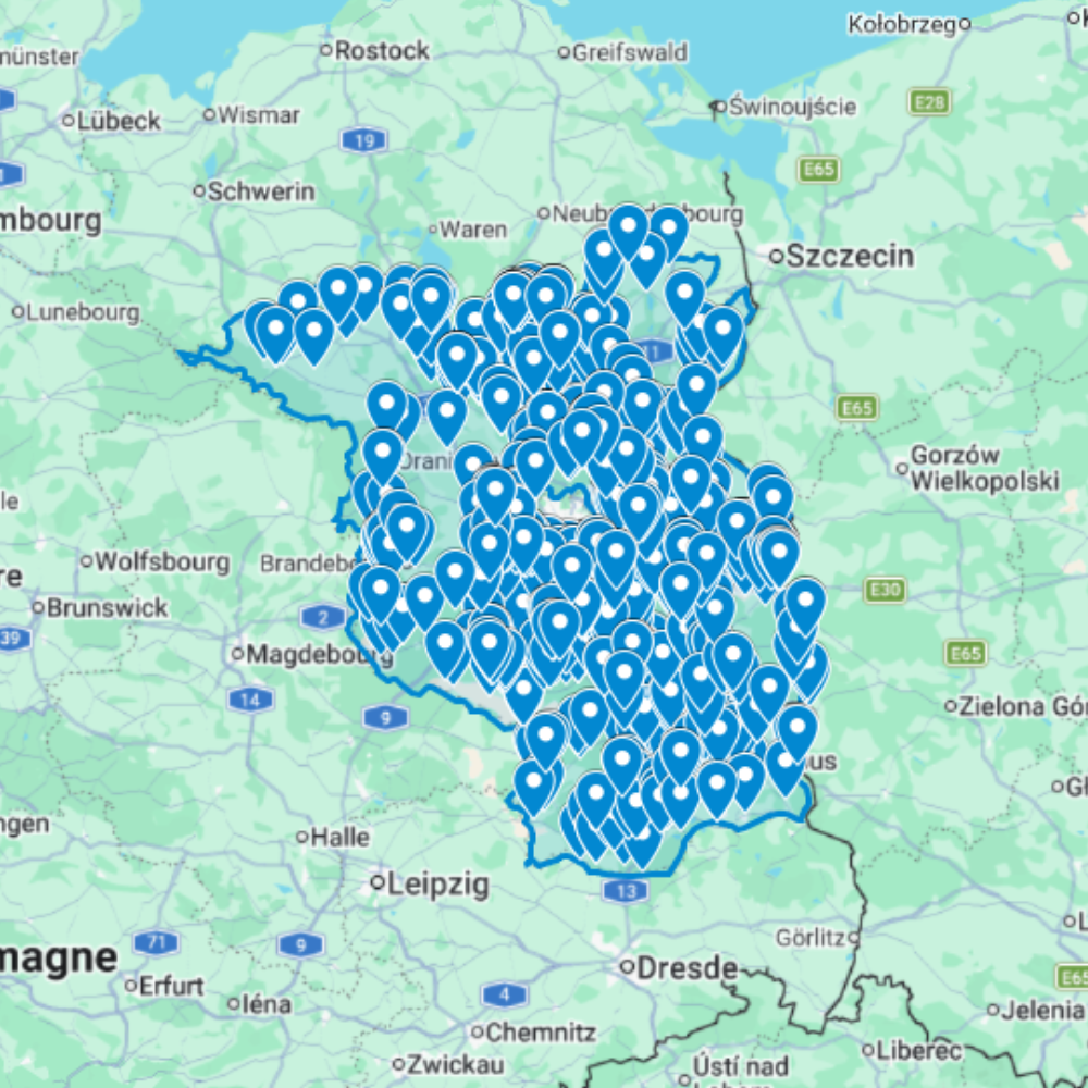
The Urbex Map Brandenburg is a detailed and structured abandoned places map covering the entire federal state of Brandenburg. It compiles 783 verified urban exploration spots into a practical and easy-to-use GPS file format.
Instead of spending hours searching through outdated forums, scattered coordinates, or unreliable online sources, this urban exploration map centralises essential location data into one organised digital database. Each entry helps explorers quickly identify potential abandoned buildings and plan photography sessions or exploration routes efficiently.
This urbex map includes a wide range of urban exploration spots such as industrial sites, former public buildings, forgotten infrastructure, and historic properties. By using a structured GPS map, explorers can significantly reduce research time and organise their exploration routes more effectively.
For urban explorers, photographers, filmmakers, and content creators, having a reliable abandoned places map of Brandenburg provides a valuable advantage for planning documentary work and visual storytelling.
Cities & Regions Included
- 🏙️ Potsdam & Berlin Surroundings : Potsdam and the areas immediately surrounding Berlin contain abandoned GDR-era facilities, former Soviet military installations, decaying institutional buildings, and forgotten Cold War structures set within historic royal landscape parks.
- 🏭 Cottbus & Lausitz Region : Cottbus and the Lausitz region feature massive abandoned lignite mining operations, former industrial processing plants, decaying company towns, and large-scale industrial infrastructure shaped by East Germany’s energy industry.
- 🌿 Frankfurt (Oder) & Eastern Brandenburg : Frankfurt (Oder) and eastern Brandenburg contain abandoned border-era facilities, former East German industrial buildings, decaying post-reunification structures, and forgotten spaces shaped by economic transition and population decline.
- 🌲 Rural Brandenburg & Lakes Region : Rural Brandenburg’s vast forests and lakes region offer abandoned rural estates, former agricultural cooperatives, decaying farmsteads, and isolated structures gradually reclaimed by Brandenburg’s dense natural landscape.
Types of Spots Included
This urbex map includes a wide variety of abandoned locations such as former factories, hospitals, warehouses, industrial plants, schools, hotels, military facilities, office buildings, GDR-era structures, and historic institutional buildings. Some entries feature large industrial complexes, while others highlight smaller forgotten buildings with historical or architectural significance. The diversity of locations provides excellent opportunities for photography, filming, and urban exploration documentation.
Why Choose This Urbex Map?
✔️ Verified and organised abandoned locations
✔️ Structured digital GPS format
✔️ Instant access after purchase
✔️ Saves extensive research time
✔️ Large structured database (783 spots)
✔️ Designed for serious urban explorers and content creators
Technical Specifications
- File Format: .KML / .KMZ
- Instant Digital Download
- Compatible with Google Earth
- Compatible with Google My Maps
- Works on Desktop & Mobile Devices
- Digital Product Only (No physical item shipped)
How to Install
- Complete your purchase and download the .KML or .KMZ file.
- Open Google Earth or go to Google My Maps in your browser.
- Import the downloaded file into the platform.
- Browse the GPS locations and plan your exploration routes.
Installation takes less than two minutes and works on both desktop and mobile platforms.
Reviews
There are no reviews yet.